

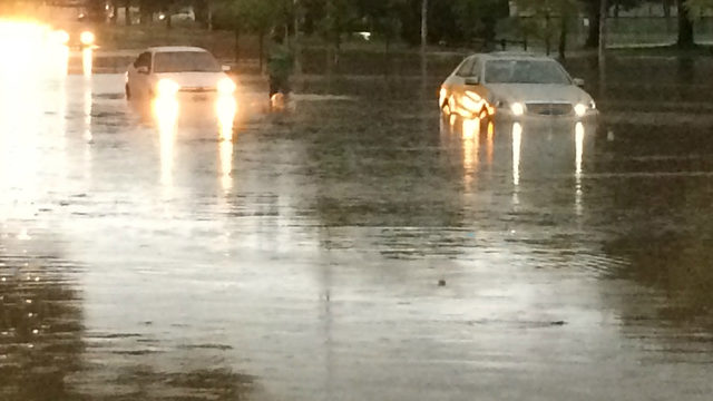
In late August, significant rainfall pummeled Madison, causing flooding throughout the city, damaging infrastructure and private residences, and costing the city millions of dollars.
According to a report by Daniel Wright, assistant professor in the department of civil and environmental engineering at UW-Madison, the amount of rain that fell on the Yahara watershed was by no means historical. Rather, Wright wrote, it fell around a 30 year recurrence interval, meaning “over the course of a 30-year mortgage, a homeowner will, on average, experience one storm similar in magnitude.”
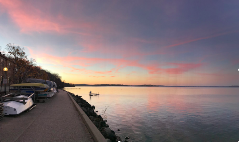
The four inches of rain that fell across the lakes produced a 100-year flood event in Madison due to the high lake levels of Lakes Monona, Mendota, Waubesa and Kegonsa — especially Lake Mendota.
The Wisconsin Department of Natural Resources set the minimum and maximum lake levels in 1979. The storm on August 20 caused the lake levels to rise well above their minimums and 100-year flood levels. And just weeks after the flooding, the lake levels for Monona, Mendota and Waubesa were still historically high, threatening more flooding.
Lake Mendota was especially culpable in the August floods for several reasons. First, the water level of Mendota sits five feet higher than its natural level. In addition, before the storm hit, Mendota’s water level was almost a foot higher than the summer maximum.
Consistent and high water levels are important for those who live on the lake and maintain a pier and a boat. Lower lake levels cost homeowners more — repairs to boats that hit the shallows and extending a pier come with high price tags.
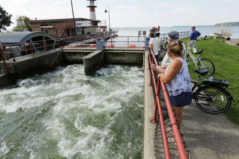
But the price is also high when significant rainfall hits the Yahara watershed. Mendota’s level is already high enough that it cannot hold any more water. Therefore, the Tenney Lock and Dam is opened, and excess water flows downstream to the other lakes, boosting their already-high water levels.
The county’s lake management philosophy centers on the lakes operating together in unity, said John Reimer, assistant director of Dane County’s land and water resources department. Reimer oversees the operation of the three dams in the county, and his department coordinates with other neighboring regions when releasing or holding water.
Reimer’s department tries to keep the lake levels relatively equal; if one lake is high, so are the others. If Lake Mendota was emptied to prevent flooding, the other lakes would take on that water, causing flooding in other areas of the county.
“We try [to] manage it as a system, so all lakes … share the same happiness and, of course, flooding levels,” Reimer said.
Why are lake levels rising?
Climate change plays a role in rising lake levels and the extreme weather events that lead to flooding in Madison. According to the National Climate Assessment by the U.S. Global Change Research Program, heavy downpours are increasing in frequency and intensity nationally, but especially in the Midwest.
Midwestern states saw a 37 percent increase in the amount of precipitation that fell during heavy events between 1958 and 2012, and research indicates that trends toward extreme precipitation will continue.
“The more extreme events we have, the more water is coming into this system and causing higher water levels,” said Reimer.
Precipitation has been increasing overall, too. Madison saw a 10 to 15 percent increase in general precipitation between 1991 and 2012.
Abundant rainfall can cause higher water levels, and it’s not necessarily the extreme events that lead to flooding, said Reimer. Smaller storms pose a serious threat, too.
“These are big lakes, and they store water, and they may not be able to release it as quickly as what comes in,” Reimer said. “If we get a rainfall today [of] one inch, but then we get another rainfall tomorrow of another inch, it all keeps adding up and keeps filling up.”
Other man-made causes lead to high lake levels and flooding. The Yahara River Watershed has two times more urban development than it did in 1970, and the urbanization of the area resulted in the watershed losing 70 percent of its wetlands, which store water and reduce flooding peaks by up to 60 percent.
An acre of wetlands can store roughly 1.5 million gallons of water, which otherwise would flood developed areas.
Urbanization means more impervious surfaces that fail to absorb water, like roads and parking lots. Therefore, instead of soaking into the ground, water runs off the surface and into the lakes.
“We've developed a lot more in a lot of different ways that lead [the area] to have less capacity to absorb the water, and so water runs off, and that's really the problem,” said Peter Taglia, a hydrogeologist and energy and environmental consultant. “If we were to slow down the water and infiltrate it in the way that was done pre-development, we wouldn't have these kind of catastrophic problems.”
Rising lake levels and consequential flooding have a series of environmental and economic impacts.
High water levels cause shoreline erosion, both along the lakes’ shorelines and wetland shorelines. When shoreline erosion occurs in the lakes, more sediment enters the lakes. In some areas, sediment has high levels of phosphorous and nutrients, which cause concerns for water quality. And, shoreline erosion leads to navigation issues for people boating and access problems for those fishing.
In the wetlands, shoreline erosion can cause plants native to wetlands to detach, leading to a loss of diversity in the wetland ecosystem.
The urban area of Madison and its residents faced significant impacts on their ability to move around. Road and bicycle path closures and infrastructure damage caused challenges for commutes and daily living.
Flooding costs for city residents included damage repairs, as well as electricity costs. High water levels at private residences are removed by a home’s sump pump, which pumps water out at a higher frequency the more there is. Taglia said his neighbor’s electric bill doubled, even though their home and property were not flooded out.
As of September, the flooding caused more than $200 million in damage in southern Wisconsin. Dane County has approximately $155 million in damage, and more than 1,500 residences have been affected, but officials expect the number will continue to grow.
Taglia guesses the economic impact of flooding could be easier to prevent in the future, whereas other impacts are harder to foresee and prevent.
“The bigger question is, how do you handle a change in climate that is bringing water and more intense floods at the same time we’re increasing impervious surfaces in the watershed?” Taglia said. “Those are obviously very expensive and call for a more radical or a more abrupt change in the business as usual.”
Lake level policy options
Looking toward past data, Reimer said the last major flooding events occurred in 1993, 1996, 2000 and 2008.
“These are on this five or 10 year period where we see these events more frequently happening,” he said. “Is it surprising? Probably not because this is what the history has show us, [that] over the past 25, 30 years, these are more commonly occurring.”
Local residents can implement changes on their own properties to protect from flooding. Taglia recommends installing retaining walls, diverting gutters away from the street, and rain gardens to control water that falls on private property and prevent erosion.
Rain gardens are depressions in the ground filled with vegetation where runoff from roofs, pavement like driveways and walkways, sloped lawns and gutters can accumulate and absorb into the soil. They are self-cleaning, and sediment won’t run off because the vegetation incorporates deep-rooted perennials.
“It’s a fantastic way of controlling the water that falls on your property and preventing it, encouraging it to infiltrate into the ground, which slows it down, preventing it from running off directly into the lake,” Taglia said.
Potential changes in Wisconsin’s environmental policies could decrease the threat of future flooding and ease the potential cost of associated damage.
“Lake levels fundamentally [are] determined by how much flow we have,” Reimer said. “The reason we have flooding is we have more flow coming in than we have leaving. So either we need to reduce the amount of flow coming in … or it’s getting more water out of the system quicker.”
Policy changes can either affect the landscape or the waterways to reduce lake levels.
Reimer has suggested incorporating retention basins in land development, which allow certain areas to flood more and store the water.
Taglia further described installing a solar-powered pump system in storm sewers, which allow the sewers to operate and drain when water levels are high. But that type of system, even when powered in an environmentally-friendly and cost effective way, compared to a coal utility like Madison Gas and Electric, is still expensive and diverts funds from policies that could have greater impacts on reducing lake levels.
One such policy involves subsidizing farmers to control water that falls on their land by using cover crops to slow erosion and increase water availability through greater absorption and installing buffer strips, small portions of land that host permanent vegetation, to reduce flooding and soil erosion.
Stricter standards surrounding runoff allowed from new developments are an option, too. But developers resist high costs, and former Wisconsin Gov. Scott Walker who supported big businesses and developers, signed a bill forbidding local governments from adopting runoff standards more stringent than the statewide standards that allow developers to essentially double the amount of runoff from their properties.
Stronger protections for the the Yahara watershed’s wetlands could help decrease flooding, but state officials have reduced environmental protections for those areas.
On February 1, the Assembly Committee on Regulatory Licensing Reform voted to remove protections on wetlands, allowing for destruction and development of those areas. The Wisconsin Wetlands Association estimated that removing protections, including replacement provisions and local authorities’ ability to protect wetlands through zoning laws, would result in a net loss of wetlands throughout Wisconsin.
In terms of adjusting waterways, Reimer suggest cleaning out areas with large amounts of accumulated sediment or widening areas constricted by bridges to allow water to flow and leave the system at a faster rate.
The most contentious policy option in Taglia’s eyes is adjusting the minimum and maximum standards set by the DNR for lake levels, essentially draining the lake by several feet and effectively decreasing the water level.
Again, those who live on Lake Mendota want the water level to be kept at an artificial height for boating and property reasons. But residents living downstream around Lakes Monona, Waubesa and Kegonsa argue they suffer from unnecessary flooding and erosion because water is let out too quickly from Mendota following heavy rainfall in order to prevent a dam break.
Advocates for lowering Lake Mendota’s water level would allow the lake to store more rain, which would subsequently prevent flooding and land damage downstream as the water it released at a slower pace.
But the last time a Yahara Lake Advisory Group was established under Gov. Jim Doyle for the second time, it was one vote short of recommending lowering the lake level for Lake Mendota, despite the group being dominated by big boating interests, according to Taglia.
Dane County Executive Joe Parisi included $18 million in the 2019 budget proposal to address flood-related damage and flood prevention efforts.
Roughly half of the funds will be dedicated to purchasing land with high levels of water runoff and restoring them to prairie areas. Farmers and landowners will potentially receive funds to enact measures to reduce soil erosion and promote water absorption.
In addition, money would be allocated for the Urban Water Quality Grant Program to fund stormwater control projects locally.
But, Parisi admitted when announcing the budget proposal, efforts to reduce future flooding and address high lake levels need to be comprehensive, not individualized.
“There's just too much water coming in than they can deliver out. It's like your bathtub , if you've got a clogged bathtub and you've still got the faucet running, it's going to fill up,” Reimer said. “It's going to keep filling up unless you can clear the clog in the drain. So that's kind of where we're at. Do we clear the clog in the drain or can we meter the water coming in?”